Solutions
Our Specialized Teams
We are composed of experienced, practical, and creative thought leaders and practitioners who all share a common passion for nature conservation. Currently, we have five specialized, solutions-oriented teams:
Biodiversity Solutions Team
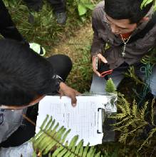
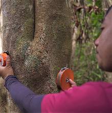
The Biodive Team is responsible for studying the biological integrity of CCIPH’s project sites by going into the field to collect and analyze firsthand data on wildlife and habitat conditions. The Biodiversity Solutions Team, or simply Biodive, is mainly responsible for studying the biological integrity of CCIPH’s project sites. Part of their work is going into the field to collect and analyze firsthand data on wildlife and habitat conditions, to be used for conservation plans, both for government-protected areas and privately-owned lands.
The team is highly trained in species distribution modeling (SDM), which is a tool for determining viable habitats for target species. Consisting of specialists in the fields of conservation biology, herpetology, and botany, the Biodive team is greatly invested in the development of the High Conservation Value (HCV) – Natural Capital Accounting (NCA) Framework for the Philippines. The team strives to incorporate new and better science-based approaches to further the biodiversity scene in the Philippines.
Geospatial Solutions Team
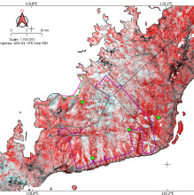
The GST is tasked with the responsibility of translating maps and interpreting views of Mother Earth into useful visual information to help solve conservation problems. The Geospatial Solutions Team, or Geo team, is tasked with the responsibility of translating maps and interpreting views of Mother Earth into useful visual information to help solve conservation problems and, well, make conservation work.
The team is composed of practitioners in the fields of geography, geomatics, marine geology, and eco-disaster preparedness, further reinforced by specialists vested with licenses to exercise their professions from the allied disciplines of geodetic engineering, geology, forestry, agricultural and biosystems engineering, environmental planning, and unmanned aviation.
Carbon Solutions Team
The Natural Assets Solutions Team is in charge of conducting carbon stock assessments in various sites in the Philippines and providing nature-based solutions for the reduction and removal of emissions from the atmosphere. The Carbon Solutions Team is responsible for conducting carbon stock assessments in various sites in the Philippines. They help develop and provide nature-based approaches and solutions for the reduction and removal of emissions from the atmosphere. This, in turn, also offers several significant benefits to the conservation initiatives of CCIPH–improving the resilience and ability of ecosystems and communities to adapt to the harsh impacts of climate change today.
Community Conservation Solutions Team
The Community Conservation Solutions Team is responsible for assessing areas important to wildlife and communities that may have been degraded due to any natural and anthropogenic activities and would need further assistance in restoration. They create a better understanding of the direct and underlying causes driving land use activities, thus providing CCIPH with essential data support significant in developing and designing action plans and framing appropriate interventions to protect the forests, adapt to and help reduce the effect of climate change.
Technology Solutions Team
TechLab is at the helm of deploying new conservation technologies and demonstrating their use and applicability to level up biodiversity monitoring projects and enhance data capture. Also known as the Wildlife Technology Laboratory, or TechLab, is responsible for deploying conservation technologies and demonstrating their use and applicability to level up biodiversity monitoring projects. They engage with “tech-for-wildlife” experts and end-users to trade knowledge and skills and learn the capabilities of these conservation techs for data capturing, monitoring, analysis, and management. Techlab is dedicated to helping the government and communities gain access to conservation tech and build capacities to lift their work to the next level by maximizing science and technology to support planning and decision-making.
CCIPH Tools and Services Offerings
At CCIPH, we believe conservation requires more than just passion. It demands innovative approaches, effective solutions, and a vast arsenal of tools and technologies.
Study of Land-Use Change
This involves examining how land is used, allocated, and managed to evolve. It seeks to understand the drivers, patterns, consequences, and implications of changes in land use and land cover.
This involves examining how land is used, allocated, and managed to evolve. It seeks to understand the drivers, patterns, consequences, and implications of changes in land use and land cover. Land use change is a critical topic due to its impact on ecosystems, economies, societies, and the environment. Overall, it provides insights into the complex interactions between human activities, the environment, and the broader ecosystem. It helps inform sustainable land management practices, conservation efforts, and policies aimed at balancing economic development and environmental protection.
Using Machine Learning Tools for Ecological Modeling
Ecological modeling is the practice of creating simplified representations of ecological systems to better understand, predict, and analyze how various components of ecosystems interact and how they respond to environmental changes.
Ecological modeling is the practice of creating simplified representations of ecological systems to better understand, predict, and analyze how various components of ecosystems interact and how they respond to environmental changes. Ecological modeling serves as a bridge between theoretical concepts in ecology and real-world observations, helping researchers test hypotheses, make predictions, and inform decision-making. Machine learning, on the other hand, involves algorithms that enable computers to learn patterns and make predictions from data. Ecological understanding, domain expertise, and validation with real-world data are critical to ensure that the models produced are accurate, meaningful, and aligned with ecological principles.
HCVA Assessment
High Conservation Value Area (HCVA) assessments play a crucial role in promoting effective and sustainable conservation practices as they provide the data and framework needed to prioritize conservation efforts, minimize development impacts, and find solutions that balance the needs of both conservation and local communities.
HCVA are natural areas containing significant concentration of biodiversity e.g. endemic and threatened species, providing basic environmental services and culturally important to local communities (FSC 2002). They are areas where biological, and ecological. Social or cultural values that are considered outstandingly significant or critically important, at the national, regional, or global level. The High Conservation Value Areas-Natural Capital Accounting (HCVA-NCA) Framework, also known as Sukat ng Kalikasan, is one of the key building blocks of USAID SIBOL’s approach in identifying conservation targets and will be instrumental in determining the protection levels and management regimes of PAs. It is meant to provide science-driven, evidence-based, and standardized practical guidance for the national interpretation of HCVs in the country. The Framework will be key in determining the protection levels and management regimes of PAs by identifying ecological values such as species survival envelopes, species niche, unique ecosystems, and habitats, rate of forest degradation, ecosystem services, as well as social, economic, and cultural values.
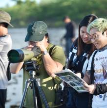
Citizen Science
Citizen science is the practice of public involvement in scientific research, allowing regular people, without necessarily having a formal science background, to contribute to scientific projects e.g. collecting environmental information that contributes to expanding our understanding of the natural environment.
Citizen Science is the term used to describe when members of the public collect environmental information that contributes to the expansion of our understanding of the natural environment. Although the term ‘Citizen Science’ is somewhat new, the practice itself goes back decades and includes activities such as biological recording, environmental monitoring, and volunteer surveys.
Citizen science already contributes substantially to many domains of science, including conservation, natural resources, and environmental science. It informs natural resource management, environmental protection, and policymaking and fosters public input and engagement. When properly designed, carried out, and evaluated, citizen science can provide sound science, efficiently generate high-quality data, and help solve problems. Citizen science has come of age in the last couple of decades since the widespread use of Internet-connected devices such as smartphones and laptops.
Forest Carbon Financing
Forest carbon financing, also referred to as forest carbon credits or carbon offsetting through forests, is a financial mechanism that seeks to alleviate the effects of climate change by encouraging the preservation and sustainable management of forests.
Forest carbon financing, also known as forest carbon credits or carbon offsetting through forests, is a financial mechanism that aims to mitigate climate change by incentivizing the preservation and sustainable management of forests to capture and store carbon dioxide (CO2) from the atmosphere. Forests play a crucial role in sequestering carbon as trees absorb CO2 during photosynthesis and store it in their biomass and soil. When forests are cut down or degraded, this stored carbon is released back into the atmosphere, contributing to greenhouse gas emissions and climate change. Carbon finance has already been widely employed to protect existing forests or improve their management.
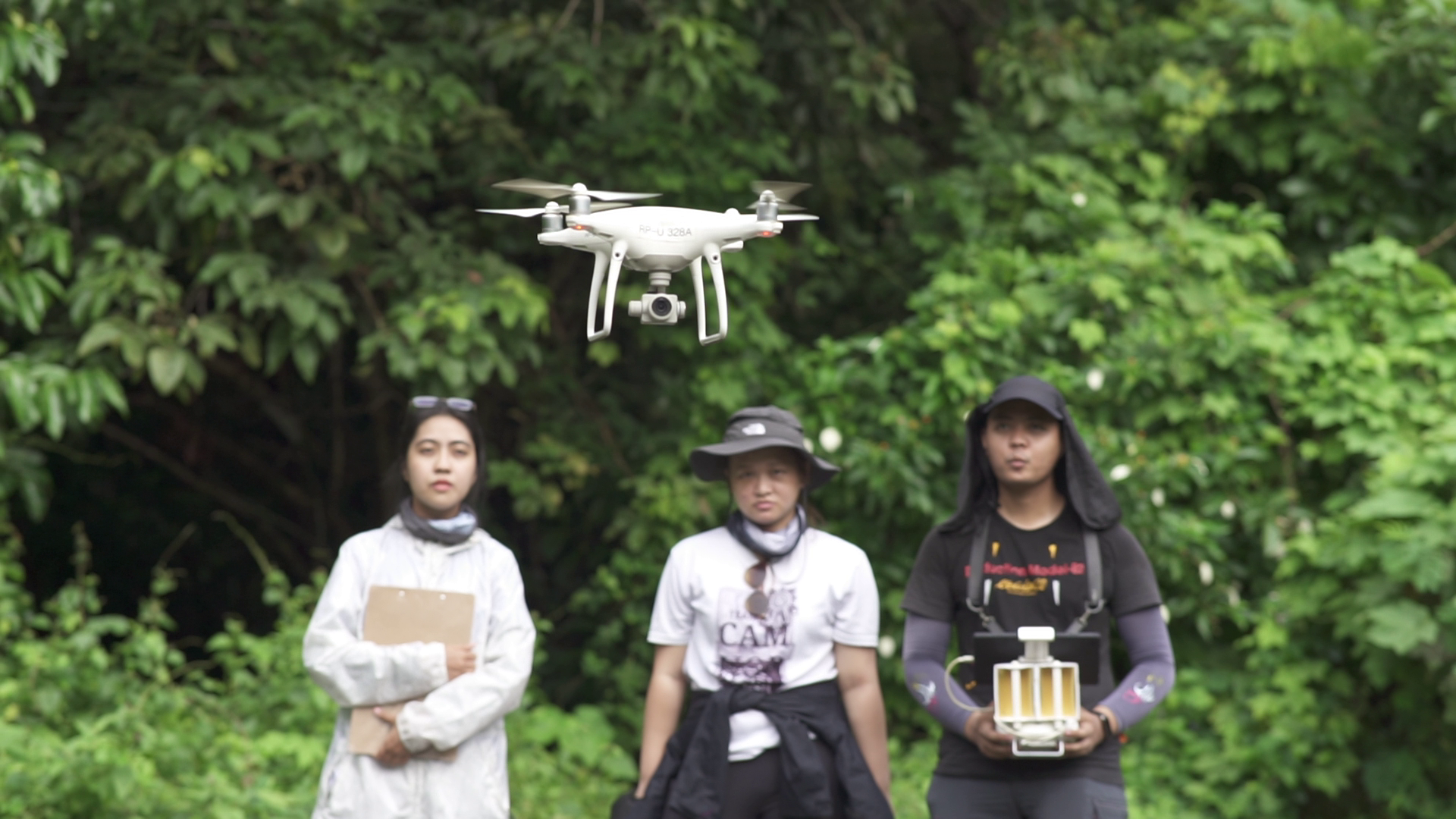
Drone Mapping
Drone mapping, also known as aerial mapping or Unmanned Aerial Vehicle mapping, is the process of using drones equipped with cameras, sensors, and GPS technology to capture high-resolution aerial images and data of the Earth’s surface.
Drone mapping, also known as aerial mapping or UAV (Unmanned Aerial Vehicle) mapping, is the process of using drones equipped with cameras, sensors, and GPS technology to capture high-resolution aerial images and data of the Earth’s surface. These images and data are then processed to create detailed, accurate, and up-to-date maps, 3D models, or other geospatial products. Drone mapping has a wide range of applications in various industries, including agriculture, construction, land surveying, environmental monitoring, and more. Drone mapping plays a crucial role in conservation efforts by providing valuable tools and data for monitoring, research, and management of natural ecosystems and wildlife. They are particularly useful in Habitat Assessment and Monitoring, Wildlife Surveys and Monitoring, Ecosystem Health Assessment, Mapping and Conservation Planning, Restoration and Reforestation, Biodiversity Research, Environmental Impact Assessment, and Climate Change Monitoring.
Eco-DRR
Ecosystem-based Disaster Risk Reduction is an approach to disaster risk reduction (DRR) that focuses on using and preserving natural ecosystems as part of strategies to reduce the vulnerability of communities to natural disasters.
Ecosystem-based Disaster Risk Reduction is an approach to disaster risk reduction (DRR) that focuses on using and preserving natural ecosystems as part of strategies to reduce the vulnerability of communities to natural disasters. Eco-DRR recognizes that healthy ecosystems provide a range of essential services that can help mitigate the impacts of disasters and enhance resilience. It promotes interdisciplinary and integrated approaches to disaster risk reduction and often involves collaboration between environmental, humanitarian, and development organizations to develop holistic strategies. Eco-DRR emphasizes adaptive management approaches that allow for flexibility and adjustment in response to changing conditions while aligning with broader sustainable development goals and climate change adaptation strategies. As climate change continues to increase the frequency and severity of natural disasters, Eco-DRR approaches are becoming increasingly important in safeguarding vulnerable communities and ecosystems.
Species Distribution Modeling
Species distribution modeling (SDM) is a set of procedures, definitions, and techniques built on a foundation of core ecological and biogeographical concepts about the relationship between species distributions and the physical abiotic environment.
Species distribution modeling (SDM) is a methodology – a set of procedures, definitions, and techniques – built on a foundation of core ecological and biogeographical concepts about the relationship between species distributions and the physical abiotic environment. SDMs are quantitative, empirical models of species–environment relationships typically developed using species location data (occurrence, abundance) and those environmental variables thought to influence species distributions. Species distribution modeling has various applications in ecology, conservation, and natural resource management, including assessing the potential impacts of environmental change (e.g., climate change, land use change) on species distributions; identifying priority areas for conservation and habitat restoration; informing land use planning and management decisions; and studying the ecological niche and habitat preferences of species.
Autonomous Vehicle Surveying
Autonomous Vehicle Surveying or AVS refers to the use of autonomous or self-driving vehicles to gather data and information about various aspects of the environment.
Autonomous Vehicle Surveying or AVS refers to the use of autonomous or self-driving vehicles to gather data and information about various aspects of the environment. This process often involves equipping autonomous vehicles with sensors, cameras, LiDAR (Light Detection and Ranging), radar, GPS, and other technologies to collect data as they navigate their surroundings. Some of its common applications in conservation work include mapping and cartography, where autonomous vehicles can create highly detailed and up-to-date maps of roads, infrastructure, and terrain, and environmental monitoring, where the AVs can be used to collect data on air quality, temperature, humidity, and other environmental factors. This information is crucial for studying climate change and pollution.